
Topic: Geocentric Model Heliocentric Model
Geocentric Model Heliocentric Model
Scientists who proposed the Big Bang Theory were attempting to explain
(1) the origin of the universe
(2) why stars have different luminosities
(3) the formation of our solar system
(4) how Earth’s atmosphere evolved

Which color and texture of Earth materials absorbs the greatest amount of short-wave radiation from the Sun?
(1) light color and smooth texture
(2) light color and rough texture
(3) dark color and smooth texture
(4) dark color and rough texture
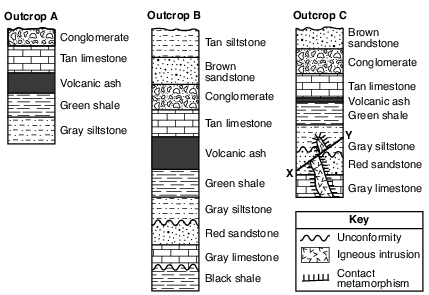
Which characteristic of the volcanic ash layer is most useful for correlating rock layers in outcrops A, B, and C?
(1) The ash was deposited over a large geographic area.
(2) The ash layer varies in thickness.
(3) Carbon-14 can be used to determine the age of the ash.
(4) Igneous rock particles are found in the ash.
What best explains why, in early spring, ice remains longer on Lake Erie than on the surrounding land areas when the air temperature is above freezing?
(1) Water has a higher specific heat than land.
(2) Energy is needed for water to evaporate.
(3) Cool winds from the surrounding land cool the ice on the lake.
(4) Air temperature does not affect water temperature.
The graph below shows changes in carbon dioxide concentrations in Earth’s atmosphere over a 140-year period. Carbon dioxide concentrations are shown in parts per million (ppm).

This significant change in CO2 concentration is most likely caused by
(1) decreased cloud cover, and is predicted to decrease average global temperatures
(2) decreased volcanic activity, and is predicted to increase average global temperatures
(3) increased use of fossil fuels, and is predicted to increase average global temperatures
(4) increased El Niño activity, and is predicted to decrease average global temperatures
A cross section of Niagara Falls is shown below.
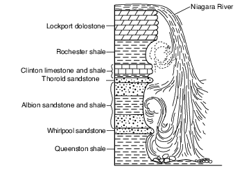
Which two rock units appear to be most resistant to weathering and erosion?
(1) Lockport dolostone and Whirlpool sandstone
(2) Rochester shale and Albion sandstone and shale
(3) Clinton limestone and shale and Queenston shale
(4) Thorold sandstone and Queenston shale
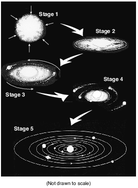
Which force was mostly responsible for the contraction of the gas cloud?
(1) friction
(2) gravity
(3) magnetism
(4) inertia
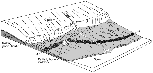
Which feature will most likely form when the partially buried ice block melts?
(1) drumlin
(2) moraine
(3) kettle lake
(4) finger lake
Carrara Marble
Carrara marble is named for the town of Carrara on the west coast of Italy. This dazzling white marble has been mined since the time of the ancient Romans and remains the major industry of the area today. The marble has many commercial uses, such as tombstones, countertops, tiles, and building stones. Its chemical purity, uniform color, and hardness make this marble an ideal material for artists who carve statues from rock. Major museums around the world have statues carved from Carrara marble.
The formation of Carrara marble began 200 million years ago when a great thickness of tiny shells was deposited at the bottom of a warm, shallow sea. Over time, burial and compaction of these sediments formed sedimentary rock primarily composed of pure calcite. Approximately 27 million years ago, tectonic forces caused this area of the seafloor bedrock to be deformed and metamorphosed, forming the Carrara marble. Uplift and erosion later exposed huge formations of this famous marble.
In terms of mineral properties, explain why a statue is easier to carve from pure white marble rather than from pure white quartzite. [1]
Allow 1 credit. Acceptable responses include, but are not limited to:
• — The mineral that makes up quartzite is harder than the mineral that makes up marble.
• — The hardness of calcite is only 3 while the hardness of quartz is 7.
• — Marble is softer than quartzite because it is made of calcite, a softer mineral.
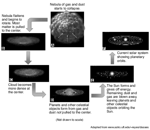
Identify the force that pulled most matter to the center of the rotating disk in stage B. [1]
Allow 1 credit for gravity or gravitation or gravitational pull.

Identify the city on the map where the altitude of Polaris is closest to 45 degrees. [1]
Allow 1 credit for Massena.
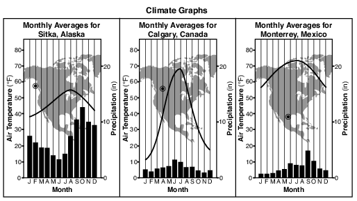
State one reason why the annual temperature range of Calgary, Canada, is greater than the annual temperature range in Sitka, Alaska. [1]
Allow 1 credit. Acceptable responses include, but are not limited to:
• — Calgary is surrounded by land, which has a lower specific heat than water.
• — Sitka is located near a large body of water, which has a higher specific heat than land
• materials.
• — The large body of water near Sitka moderates the temperature.
• — Calgary has a continental climate, while Sitka has a maritime climate.
• — Calgary is farther inland.

A solar eclipse could occur when the Moon is located at which numbered position? [1]
Position number:
Allow 1 credit for position number 8.
Frozen Mammoth
A wooly mammoth was found in 1999 buried in the frozen soil of the Siberian tundra. Carbon-14 dating indicated that it had died about 20,000 years ago. Many fossils represent only the partial remains of organisms. However, a complete mammoth with bones, skin, hair, and internal organs intact represented a unique opportunity for scientists to investigate the lifestyle of this animal and the environment in which it lived.
The low permeability of the tundra soil helped to preserve the mammoth. Explain why the tundra soil has a low permeability. [1]
Allow 1 credit. Acceptable responses include, but are not limited to:
• — The rate at which water infiltrates the soil will decrease if the soil is frozen.
• — Frozen ground is mostly impermeable.
• — Ice fills the pore spaces.
• — The ground is frozen.
• — The soil is composed of small particles.
The Great Rift Valley
Rifting of Earth’s crust in eastern Africa began during the Neogene Period as the Ethiopian and Kenyan Domes formed. These two huge domes were created as Earth’s mantle pushed up the overlying crust. As the crust was forced upward, the resulting tension cracked the crust, resulting in the eruption of volcanoes and the formation of large rifts. The crust continued to pull apart, forming rift valleys. These valleys have become deeper and are currently becoming filled with sediments, igneous rock, and water.
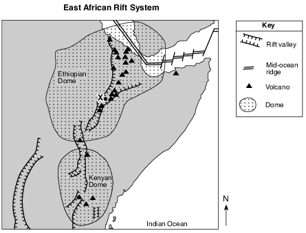
How many million years ago did the Ethiopian and Kenyan Domes form? [1]
million years ago
Allow 1 credit for any value from 23 million years ago to 1.8 million years ago.